Tintagel and the Battle of Camlann

Tintagel Castle

Modern sculpture of King Arthur on the summit of Tintagel Island.

Although this blogpost briefly mentions Scotland it is mainly about the far south-west corner of England. It does however deal with the early medieval period and with another of the ‘Celtic’ regions of Britain. It is one of a number of non-Scottish posts that occasionally appear here at Senchus.

* * *

A holiday on the north coast of Cornwall last year gave me an opportunity to visit a couple of places associated with King Arthur. One was Tintagel Castle, a strikingly impressive site that I was lucky enough to explore on a warm, cloudless day. The other was Slaughterbridge, a Cornish candidate for Camlann – the site of Arthur’s final battle where both he and his treacherous nephew Mordred were said to have perished.

Battle of Camlann

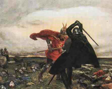
Arthur and Mordred in combat at Camlann, painted by William Hatherell (1855-1928)

The question of whether or not the Arthurian legend preserves the authentic story of a sixth-century warlord called Arthur/Artorius is, of course, a matter of debate. My own thoughts on this controversial topic appeared most recently as a chapter in Scotland’s Merlin, published by Birlinn Books in 2016. For the record, I currently favour south-west Scotland as a possible source of the Arthurian legend’s original core, but this does not necessarily mean that I see Arthur himself as any more ‘real’ than Batman. Maybe Arthur existed, maybe he didn’t. The question is not, in any case, a crucial one for historians of early medieval Britain. Hence, Arthur’s story is frequently absent from modern textbooks on the period, including my own study of the Britons of southern Scotland (The Men Of The North, published in 2010). I nevertheless retain an interest in Arthur’s legend – and Merlin’s too – especially at places with tangible ‘Dark Age’ connections. In Cornwall, both Tintagel and Slaughterbridge fall into this category, each of them being sites where objects from the sixth century – the time when Arthur supposedly existed – can still be seen today.

map_cornwall_map2

Tintagel Castle

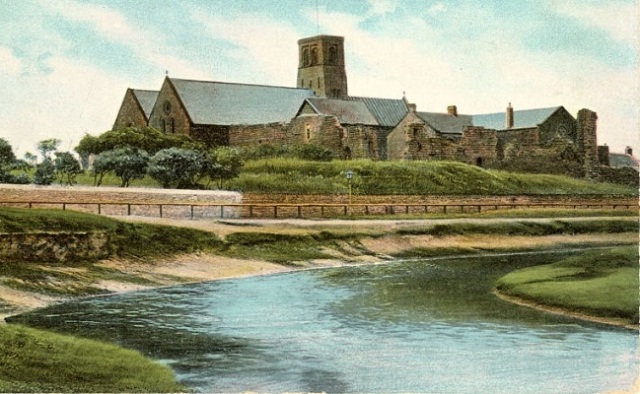
Old engraving of Tintagel Island and the castle ruins.

Tintagel

The island of rock now crowned by Tintagel’s medieval castle formerly supported a substantial high-status settlement occupied in the ‘Arthurian’ era of the fifth and sixth centuries AD. Archaeological excavations have unearthed artefacts and structures from this period, ranging from pottery and glassware to traces of buildings. The pottery includes large jars (amphorae) that once contained wine imported from Mediterranean lands. These show that Tintagel’s inhabitants were involved in long-distance trading networks with other parts of what had once been the Western Roman Empire. Plenty of information about the archaeological finds is available online and I have included a couple of links at the end of this blogpost.

For many visitors, what attracts them to Tintagel Castle is its claim to be the place where Arthur was conceived. The claim derives from the twelfth century when Geoffrey of Monmouth’s History of the Kings of Britain described how Arthur’s father, King Uther Pendragon, used deception to satisfy his lust for Lady Igraine, the beautiful wife of Duke Gorlois of Cornwall. A potion concocted by Merlin enabled Uther to disguise himself as Igraine’s husband so that he could spend the night with her in the Duke’s stronghold at Tintagel. The offspring of this deceitful liaison was Arthur, who eventually succeeded to Uther’s throne.

Whatever our opinions on Geoffrey of Monmouth’s value as a source of early British history, there is no doubt that he knew how to tell a good tale. His dramatic account of Uther and Igraine ensured that Tintagel would forever have a place in Arthurian lore. Needless to say, the teams of archaeologists who have excavated there (most recently in 2018) have found no trace of Geoffrey’s characters – despite the discovery in 1998 of a stone inscribed with the suggestive name Artognou. Yet the popular belief that this was a place well-known to Arthur and Uther 1500 years ago is still alive in the popular imagination.

The following photographs give an idea of what the modern visitor to Tintagel Castle can expect to see.

Tintagel Castle

Tintagel Castle

Looking back from the castle ruins on the summit of Tintagel Island to the adjacent mainland.


Tintagel Castle

Looking along the coast of North Cornwall from the ruins of Tintagel Castle.


Tintagel Castle

The outlined shape of a rectangular building from the 5th/6th century settlement.


Tintagel Castle

Information board for a group of excavated ‘Dark Age’ buildings.


Tintagel Castle

A pair of early medieval buildings nestling on the slope below the summit.


Tintagel Castle

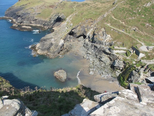
Looking down from the castle to a small cove and beach.


Tintagel Castle Merlin's Cave

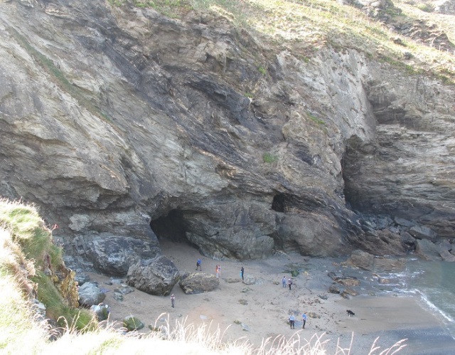
In the cliffs below the castle lies Merlin’s Cave (the cave on the left).


Slaughterbridge

According to the ancient chronicle known as Annales Cambriae (‘Welsh Annals’), the year 537 witnessed the bloody battle of Camlann in which Arthur and Mordred were slain. The antiquity of this information is uncertain and cannot, on present evidence, be shown to pre-date the tenth century when the Welsh Annals were compiled. Two hundred years later, in the 1130s, Geoffrey of Monmouth placed Camlann in Cornwall, on the River Camel. Cornish tradition has long located the battlefield at Slaughterbridge near Camelford, some 4 miles south-east of Tintagel. Another candidate for Camlann is the Roman fort of Camboglanna (now Castlesteads) on Hadrian’s Wall. Camboglanna is a Celtic name borrowed by the Romans. It means ‘crooked valley’ in the old language of the Britons and could have become Camlann in medieval Welsh. However, there were no doubt many crooked valleys in Roman Britain, so the name Camboglanna might have been a common one. It is also possible that Camlann derives from a different name such as Cambolanda (‘crooked enclosure’).

At Slaughterbridge there is a fascinating visitor attraction called The Arthurian Centre which tells of the local Camlann tradition. The Centre has a tearoom, gift shop and plenty of information on Arthur, as well as a walking trail over part of the presumed battlefield beside the River Camel. The trail meanders through pleasant woodland and ends at a viewing platform above the river. Below the platform, and close to the water’s edge, lies a remarkable Early Christian gravestone from the sixth century. It is carved with a Latin inscription: LATINI IC IACIT FILIUS MA[…]RI (‘Here lies Latinus, the son of M…..’)

Along one edge of the stone runs another inscription, in the ancient Ogham script of Ireland. Although badly weathered, this has been interpreted by at least one expert as possibly containing the same name Latinus. Unfortunately, we have no idea who Latinus was. He may have been a local Briton, or perhaps an Irishman. Whatever his origins, he was clearly a person of sufficient importance to be commemorated in this way. It is interesting to note that the name also appears on another sixth-century memorial, the famous Latinus Stone from Whithorn in south-west Scotland, which marked the grave of a father and daughter.

Unsurprisingly, given the local connection with Arthurian legend, the Cornish Latinus stone has been seen in some quarters as a relic of the battle of Camlann. A separate belief associates it with a battle fought in 825 at a place called Gafulford, where the Britons of Cornwall clashed with the neighbouring West Saxons. Gafulford is thought by some historians to mean ‘Camel-ford’, but others interpret the name differently and place the battle elsewhere. The simple truth is that neither Camlann nor the ninth-century battle can be placed with certainty in the valley of the River Camel, or indeed in Cornwall.

During my visit I was saddened to learn that the inscribed stone is at risk of being harmed by floods. In fact, it has been placed on the At Risk Register, which is a matter of concern. We can only hope that this important monument will soon be protected, perhaps by standing it upright (as it formerly was) and moving it higher up the riverbank (which may have been its original position). Some kind of intervention certainly needs to happen before it is overwhelmed by the river.

Arthurian Centre in Cornwall

The trail from the Arthurian Centre, looking towards the supposed battlefield of Camlann.


Arthurian Centre in Cornwall

The sixth-century inscribed stone lying beside the River Camel.


Arthurian Centre in Cornwall

The Latin inscription.


Arthurian Centre in Cornwall

Information board on the viewing platform.


* * * * *

Notes and Links

The images in this blogpost are copyright © B. Keeling.

Readers may be interested in an article by Professor Andrew Breeze: ‘The Battle of Camlan and Camelford, Cornwall’ Arthuriana 15.3 (Fall 2005): 75-90

The Arthurian Centre has a website and a Facebook page

The Tintagel Dig on Twitter

Information on Tintagel Castle at the English Heritage website

* * * * * * *

Bede’s World reborn

St Paul's Church, Jarrow.

St Paul’s Church, Jarrow.


The Venerable Bede was an English monk who spent almost his whole life at the dual monastery of Wearmouth-Jarrow in the Anglo-Saxon kingdom of Northumbria. He wrote about the evolution of early English Christianity in his best-known work, the Ecclesiastical History of the English People, completed in AD 731. Despite its title the book is far more than a religious chronicle and contains a wealth of information on kings, kingdoms and politics in Dark Age Britain. Bede is one of our key sources on Pictish history. In fact, his book is a useful one to wave around whenever someone asks “Do we really know anything about the Picts?”

Bede

Bede on his deathbed in AD 735 (a painting by James Doyle Penrose).

Jarrow is situated on the south bank of the River Tyne. Its parish church, St Paul’s, stands on the site of the Anglo-Saxon monastery and preserves some of the original stonework. Nearby stands Jarrow Hall, an eighteenth-century mansion which opened to the public as the Bede Monastery Museum in 1974. Nearly 20 years later, in 1993, a new museum and heritage centre called Bede’s World was unveiled. This had a “living history” aspect which included representations of Dark Age farming with real animals of the type an Anglo-Saxon monk would have seen. I visited Bede’s World a couple of times and always enjoyed it. As well as the historical displays and archaeological relics it had a nice gift shop and cafe (the latter being located in Jarrow Hall). Beyond the old monastic boundary lay the post-industrial landscape of Tyneside but this just seemed to add something to the overall experience.

Anglo-Saxon window at St Paul's Church, Jarrow.

Anglo-Saxon window in the wall of St Paul’s Church at Jarrow.

However, the recession of the early twenty-first century has had a big impact on heritage tourism sites, especially those that rely on government funds to supplement visitor revenues. Bede’s World was one of the places that fell victim to the cutbacks. Despite attracting more than 70,000 visitors per year, this unique and exciting venue was forced to close its doors in February 2016.

However, the story did not end there. A few weeks after the closure, some very encouraging tidings were heard. South Tyneside Council, the landowner of the Hall and museum, announced that the venue had been saved from oblivion. A charity called Groundwork South Tyneside and Newcastle would be taking over as the new operator.

Things have moved further along in the intervening months. Last week it was reported that the site will re-open in October as “Jarrow Hall – Anglo Saxon Farm, Village and Bede Museum.”

This is all good news. I look forward to seeing the new version of Bede’s World in the autumn. If it’s even half as good as the old one it will be well worth a visit.

* * * * *

Bede

The sad tale of the closure of Bede’s World and the rather happier story that followed can be traced via the links below.

Bede’s World: Cash crisis forces closure of Jarrow tourist attraction

Bede’s World attraction in Jarrow saved from closure

Former Bede’s World museum to reopen as Jarrow Hall

More links….
Jarrow Hall – Anglo Saxon Farm, Village and Bede Museum
Jarrow Hall on Twitter
St Paul’s Church, Jarrow

Wearmouth & Jarrow: Northumbrian Monasteries in a Historic Landscape, a book by Sam Turner, Sarah Semple and Alex Turner (published in 2013).

* * * * * * *

Remembering Aethelflaed

Aethelflaed of Mercia

Aethelflaed of Mercia with her young nephew Athelstan (a modern sculpture at Tamworth Castle).


Today is the 1097th anniversary of the death of my favourite individual from the Dark Ages.

I refer, of course, to the Anglo-Saxon princess Aethelflaed, the Lady of the Mercians. She was the daughter of Alfred the Great, king of Wessex, and sister to his successor Edward the Elder.

Aethelflaed married Aethelred, the ruler of Mercia in the western midlands of England, and joined him in a programme of fortress-building that strengthened his people’s defences against Viking raids. After Aethelred died in 911, his widow became sole ruler and – unusually for a woman in those times – a commander of armies in the field. She led military campaigns in person and achieved several major victories. Working in tandem with her brother Edward, she not only held off the Viking menace but won back a number of conquered territories in eastern England.

As part of her wider anti-Viking strategy, she formed a three-way alliance with the kings of Alba and Strathclyde. This northern and Scottish dimension is one of the reasons why I have long been fascinated by her career. Another reason is her connection with Mercia, my homeland, which she governed and protected during a time of great peril and uncertainty.

She died on 12 June 918, at the ancient Mercian settlement of Tamworth.

I’ve mentioned Aethelflaed here at Senchus quite a few times and, six years ago, devoted a blogpost to her. Last year I wrote about her again, at one of my other blogs. Here are the links to those posts…
‘The Lady of the Mercians’ [Senchus blog, 2009]
‘Aethelflaed’ [Strathclyde blog, 2014]

Her alliance with the Scots and Strathclyde Britons is described in a medieval text known as The Fragmentary Annals of Ireland. The passage in question gives an idea of the high regard in which she was held by contemporaries in lands far beyond the borders of Mercia. The relevant passage, with an English translation, can be seen in my blogpost on the Fragmentary Annals.

I also recommend Susan Abernethy’s article ‘Aethelflaed, Lady of Mercia’ and Ed Watson’s ‘Aethelflaed: the making of a county town’.

I discuss Aethelflaed and her relations with the northern kings in my book Strathclyde and the Anglo-Saxons in the Viking Age (on pages 58-63).

* * * * * * *

Whitby

Whitby Abbey

Whitby Abbey


As this blogpost is about a place in England I’m putting it in my ‘non-Scottish’ category, but that’s not the whole story, because Whitby has an important connection with early medieval Scotland.

Today, Whitby is a busy town and seaside resort on the coast of North Yorkshire. Its most striking landmark is the ruined abbey on a high headland overlooking the harbour. The abbey stands near the site of an Anglo-Saxon monastery which was the venue for a hugely significant event in AD 664: an ecclesiastical synod where matters of grave concern were discussed. The synod was hosted by Abbess Hild, a princess of the English kingdom of Northumbria, who also chaired the debate. Among the attendees was the Northumbrian king Oswiu (husband of Hild’s kinswoman Eanflaed) at whose request the gathering was summoned.

At stake in the debate was the future direction of Christianity in Oswiu’s kingdom. Would the Northumbrian churches continue to follow the ‘Celtic’ religious customs of Iona, the Hebridean island monastery founded by Saint Columba? Or would they instead adopt the so-called ‘Roman’ customs practised throughout much of Western Europe? The Celtic case was put by Colmán, bishop of Lindisfarne, while the chief spokesman for the Roman side was Wilfrid, abbot of Ripon. After hearing the arguments and counter-arguments, King Oswiu decreed that the Northumbrian churches should adhere to Roman customs alone. At a stroke, Iona’s authority among the Northern English clergy was ended. Even those who felt strong loyalty to the old Celtic ways, such as Hild herself, were obliged to obey the royal command.

Nothing now remains of the seventh-century monastery at Whitby. Although archaeologists have found traces of timber buildings on the seaward edge of the headland, as well as a large cemetery of Anglo-Saxon graves beneath a car park near the Abbey, the precise layout of the monastic site is unknown. Modern visitors are instead left to imagine how the headland might have looked in Hild’s time. When they reach the top of the 199 steps leading up from the town, they encounter an impressive rendition of an Anglo-Saxon cross.

Caedmon's Cross

Caedmon’s Cross, Whitby.


This monument, known as Caedmon’s Cross, was erected in 1898 to commemorate Caedmon, a herdsman at the Whitby monastery, whose talent for poetry caught the attention of Hild. Both he and the abbess are carved on the front, together with Jesus Christ and the Israelite king David.
Saint Hild of Whitby

Caedmon’s Cross: St Hild, abbess of Whitby.


Caedmon

Caedmon’s Cross: Caedmon the poet


Caedmon's Cross

Caedmon’s Cross: commemorative text


The cross stands in the graveyard of St Mary’s Church, an interesting old building which is well worth a visit. The church has a number of stained glass windows depicting key figures connected with the Synod of Whitby (Hild, Wilfrid and Colmán) as well as Caedmon and two seventh-century Northumbrian kings (Oswiu’s brother Oswald and Hild’s kinsman Edwin).
Hild and Wilfrid

St Mary’s Church: Hild and Wilfrid


Caedmon and Colman

St Mary’s Church: Caedmon and Colmán


Finally, a Scottish connection from a rather later period: a stone memorial, high on a wall inside St Mary’s Church, honouring the English general Peregrine Lascelles (1685-1772) who fought in the battle of Prestonpans near Edinburgh in 1745. This famous Jacobite victory, in which an English army was flung into disarray by a wild Highland charge, evidently niggled the old general to the end of his days. His memorial refers to a fruitless exertion of his Spirit & ability at the disgracefull rout of Preston pans.

St Mary's Church, Whitby: memorial to General Lascelles

General Lascelles (left) and his memorial at St Mary’s Church, Whitby (right).

* * * *

All photographs in this blogpost are copyright © B Keeling.

I’ve written in more detail about the Synod of Whitby in my book on Saint Columba.

Hild has been brought vividly to life by award-winning author Nicola Griffith in a historical novel scheduled for publication later this year.

* * * * * * *

Letasia

My first post of 2013 has little connection with the topics usually featured here. It’s not about Scotland, nor any other part of the British Isles, even if it does fit with the overall theme of ‘early medieval’. It’s actually about Galicia (in the Iberian Peninsula) from where we have a charter issued by a prosperous woman called Letasia in the year 896. This document gives a fascinating glimpse (through female eyes) of ninth-century attitudes towards immorality among people whose lives were probably not dissimilar to those of their contemporaries in Britain. It comes courtesy of medieval charter expert Jonathan Jarrett in his final blogpost of 2012.

Happy New Year to all.

* * * * * * *

Bede’s ‘Wilfaresdun’

I suppose this qualifies as one of my occasional ‘non-Scottish’ blogposts as it doesn’t deal with places or events in Scotland. There is, however, a slight Scottish connection, because the main event referred to here marked a significant milestone in the career of Oswiu, king of Bernicia, whose realm included parts of what are now Lothian and the Borders.

We begin with the words of an Englishman, the Venerable Bede, writing c.730 at the Northumbrian monastery of Jarrow. In Book 3, Chapter 14 of his Ecclesiastical History of the English People, Bede tells us that two northern English kings prepared to do battle with one another in the summer of 651. One was Oswine, ruler of Deira, a kingdom roughly coterminous with the pre-1974 county of Yorkshire. The other was Oswiu of Bernicia, whose territory lay north of the River Tees and whose chief citadel lay on the imposing rock of Bamburgh. According to Bede….

“Each raised an army against the other, but Oswine – realising that he could not fight against an enemy with far greater resources – considered it wiser to give up the idea of war and wait for better times. So he disbanded the army which he had assembled at Wilfaresdun (Uilfaresdun), that is Wilfar’s Hill (Mons Uilfari), about ten miles north-west of the village of Catterick (vico Cataractone).”

But better times were not on the menu for Oswine. After disbanding his army, he sought refuge in the home of a local lord, supposedly a loyal henchman, who held land at Gilling. There he was betrayed to Oswiu and cruelly murdered, his death occurring on 20 August.

Bede says good things about Oswine, whom he regarded as a man of piety and generosity. Oswiu on the other hand emerges from the story with little credit, but went on to become one of the greatest of all Northumbrian kings, ruling Deira and Bernicia as a single realm. The story is useful in giving us an insight into the tensions that simmered between the respective Deiran and Bernician royal dynasties in the mid-seventh century, before they were brought together as a unified Northumbria in the era of Oswiu and his sons.

Two of the places mentioned in the story are easy to find on a modern map. Catterick, here referred to by Bede under its Latin name Cataracto or Cataracta, was a former Roman town on the main north-south highway running along the eastern side of Britain. It lay close to a major junction, now known as ‘Scotch Corner’, where another road branched off to Carlisle via the high moorlands of Stainmore. Gilling, which Bede called Ingetlingum, lies south of this branch-road and was the site of an Anglo-Saxon monastery. The present village is known today as Gilling West.

But where was Wilfaresdun, Wilfar’s Hill?

Historians have occasionally puzzled over this question. Some have suggested possible answers, while others have concluded that the place cannot now be identified. Suggestions have tended to focus on a belief that the place-name may have survived, with modern equivalents being sought as far afield as Wilbarston in Northamptonshire. Wilbarston is too distant to be a viable candidate but it comes under the spotlight because no similar name survives within the broad range of Bede’s “about ten miles north-west of Catterick”. In these situations the desperate search for ‘sounds like’ place-names on a modern map sometimes takes precedence over rational thought or even, as in this case, over the testimony of a contemporary chronicler. Hence we find the small North Yorkshire village of Garriston being proposed as a possibly close match to Wilfaresdun because the two names share a superficial similarity. But Garriston poses a couple of serious problems: first, it lies south-west of Catterick, an orientation that must rule it out of any serious search; and, second, it was unlikely to have ever been known as Wilfaresdun. It has the rather different name Gerdestone when it is first mentioned in the historical record (in Domesday Book in the late eleventh century). In any case, we have no good reason to doubt the geographical context given by Bede, whose information probably came from Ceolfrith, the renowned abbot of Jarrow. Ceolfrith had formerly been a monk at Gilling, where the murdered King Oswine was venerated as a saint. The Gilling monastery had been founded by Oswiu himself in atonement for the treacherous assassination of his rival.

The monks of Gilling kept alive a memory of Oswine and undoubtedly preserved authentic stories about his life. Ceolfrith would have been familiar with these tales during his time there as a novice monk. It was surely from Ceolfrith that Bede obtained his information about the location of Wilfaresdun and we can therefore take it at face value. Wilfar’s Hill, then, lay approximately ten miles north-west of Catterick. These were Roman miles, shorter than today’s measure, so the true distance in modern terms is roughly nine miles. Bede and his contemporaries had no satellite imaging or aerial photography, so their measurements of distance were based on how far a traveller had to walk or ride along roads and tracks. If we follow the Roman highway from Catterick, steering a north-west course, we soon find ourselves on the branch-road to Carlisle. There are few significant or prominent hills in the early stages of this route, for we are still in the rolling agricultural countryside of Richmondshire. In fact, there is only one noticeable landmark worthy of note. Standing on the north side of the Roman road, some eight miles out from Catterick, it rises alone from the surrounding fields and is visible from a considerable distance. Its name on modern maps is Diddersley Hill.

Diddersley Hill

The southern flank of Diddersley Hill, viewed from the Roman road.

The suggestion that this hill might be Bede’s Wilfaresdun was made by Andrew Breeze in an article published seven years ago. Having visited the location this summer I am inclined to think Professor Breeze may be right, and that Mons Wilfari has been rediscovered. I also share his belief that Diddersley Hill may have been a traditional mustering-point for the armies of Deira, not just in the summer of 651 but at other times too. It certainly fits the requirements: a conspicuous landscape feature, visible to military forces approaching along the Roman road from east or west, an ideal venue for a king to gather an army comprising the warbands of subordinate lords. It is not difficult to imagine Oswine summoning his henchmen to this place in preparation for a decisive battle with Oswiu. Perhaps it was here, on the slopes of this hill, that the Deiran king surveyed his forces and deemed them insufficient for the task.

Diddersley Hill

Diddersley Hill, viewed from the north.

Diddersley Hill

Diddersley Hill, from the north, in its landscape context.

* * * * * * *

Andrew Breeze, ‘Where were Bede’s Uilfaresdun and Paegnalaech?’ Northern History 42 (2005), 189-91.

The three photographs of Diddersley Hill are copyright © B Keeling 2012.

* * * * * * *

The monastery at Dacre

Dacre Church: front entrance and Norman tower.


In February I finally got around to visiting Dacre, a small village on the southeastern fringe of the Lake District in Cumbria. It has been on my ‘get to’ list for a long time, not only because it’s a very picturesque place but also because of its history. In early medieval times the site of the present-day church was occupied by a monastery mentioned by Bede. He described it as being ‘near the river Dacore from which it received its name’, a reference presumably to the Dacre Beck or to the River Eamont into which it flows. Bede referred to a miraculous event that occurred at the monastery in 728, during the abbacy of Swithberht. At that time one of the brethren – a priest called Thrythred – had in his possession a piece of St Cuthbert’s hair. The hair cured a young monk of an untreatable condition that would otherwise have left him blind in one eye. By 731, when Bede published his Ecclesiastical History, the abbacy had passed to this same Thrythred, but this is the last we hear of Dacre until after the Norman Conquest. The names Swithberht and Thrythred are English and indicate that the monastery lay in Anglo-Saxon (i.e. Northumbrian) hands in the early 8th century. However, we do not know the date of foundation, so we cannot assume that the monks had always been English. It is possible, for instance, that the original brethren were Britons who fled in fear of Northumbrian warbands during the conflicts of the previous century.


Dacre Church: Norman arch (12th century).


Excavations in the churchyard in the early 1980s found evidence of the monastery, even though none of its buildings has survived. One early feature was a covered drain running across the southern part of the churchyard. This was found to be lined with shaped stones that may have come from a Roman structure (possibly a bridge) somewhere in the vicinity. Archaeologists also found traces of two timber buildings – one rectangular, the other circular – slightly northwest of the present church. The purpose of these is unknown but the circular one eventually fell into disuse and its space seems to have been given over to metalworking – this, at least, is suggested by the presence of hearths and copper pins. Another discovery was a large cemetery of more than three hundred graves, the majority of which are most likely of pre-10th century date. This is presumably where generations of monks were interred and where the 8th-century abbots Swithberht and Thrythred were laid to rest.

Dacre Church: the southeast corner.


Although little evidence of the daily life of the monastery has survived, a few small items have come to light. These include a writing-stylus, a belt buckle, a gold ring and a Viking coin. Together they provide evidence of a thriving community. Inside the church two sculptured fragments testify to the site’s high status in early medieval times. Both are from cross-shafts that must once have stood within the monastic enclosure. They are, respectively, of 9th and 10th century origin. The smaller of the two is the earlier and is of typical Northumbrian workmanship, with finely detailed carvings of a serpent and a winged lion. Its sculptural style is superior to that of the larger piece which looks unsophisticated by comparison. As soon as I saw this later fragment – which is usually attributed to Norse influence – I was reminded of the similarly crude sculpture of the Strathclyde Britons. The two human figures with linked hands are reminiscent of a pair on a contemporary cross-shaft from Cambusnethan in Lanarkshire, while an animal peering backward is a common motif on several Strathclyde monuments. Thus, although ‘Viking’ is a label often applied to the two Dacre fragments, I wonder if they represent a more complex set of cultural affinities. The monastery may have undergone several changes of ownership – in terms of ecclesiastical jurisdiction and secular patronage – between Bede’s era and the Norman Conquest. In the 9th century it is likely to have been a target of Norse raids and was no doubt affected by the collapse of Anglo-Saxon Northumbria in the 860s. After c.900 its abbot probably became answerable to a new set of local lords, an immigrant elite of Cumbric-speaking Britons installed by the kings of Strathclyde. In 927 one of the Clyde kings attended a royal conference at a place called Eomotum – an unidentified site on the River Eamont. His name was Owain and he was a key player in the political manoeuvring between Viking, English and Celtic powers that eventually led to the great battle of Brunanburh in 937. The Eamont almost certainly marked the southern boundary of Owain’s kingdom and thus an appropriate setting for a meeting of kings. Indeed, Dacre’s position on one of the tributaries of this river led the 12th-century chronicler William of Malmesbury to suggest that the conference took place at the old monastery itself rather than at a site further downstream near the village of Eamont Bridge.

9th-century Northumbrian cross-shaft fragment.


Fragment of cross-shaft (10th century).


Animal and human figures on the 10th-century cross-shaft.


I’ve assigned this blogpost to the category ‘non-Scottish’ but this does not mean that Dacre had no connection with Scotland in early medieval times. Constantin II, one of the most famous kings of Alba, attended the royal meeting in 927 alongside his Strathclyde ally Owain. Both of these rulers can be regarded as ‘Scottish’ in the context of modern political geography. Even if Dacre is not the mysterious Eomotum (and I do not think it is) we cannot assume that it played no part in the meeting. We know it was an important site at the time because of the date of the larger cross-fragment. Perhaps the monastery hosted a religious service for the royal delegates after their high-level political discourse?

* * * * * * *

Appendix: The Dacre Bears

The churchyard at Dacre contains four free-standing animal sculptures, each positioned near one corner of the church. Their date and purpose are unknown, but they are usually known as the ‘Dacre Bears’. Three are too weathered to show much detail but the fourth has a mane and a long tail and is probably a lion. Two others appear to be grappling with some kind of smaller animal. What all this means is a complete mystery. Were the ‘bears’ carved in early medieval times, or do they post-date the Norman Conquest? Are they, in fact, of pre-Christian origin?

One of the Dacre Bears.

* * * * * *

Notes & References

The Church of St Andrew, Dacre (2008) [booklet produced by the parish community]. Includes at pp.29-30 an archaeological summary by Rachel Newman, ‘The early history of the church site’.

Bede, Ecclesiastical History of the English People, Book iv, chapter 32.

All photographs in this blogpost are copyright © B Keeling.

* * * * * * *

Welsh kings at the English court, 928-956

Hywel Dda

The Welsh king Hywel Dda (died 950)

Although I’ve listed this post in the ‘non-Scottish’ category it does have a connection with the blog’s overall theme. It’s basically an announcement of a new article dealing with important events of the 10th century, a period when the dominant power in Britain was the West Saxon royal dynasty. The article is mainly concerned with West Saxon policy towards Wales but the author, Kevin Halloran, considers a wider political picture in which the northern Celtic powers – the kings of Alba and Strathclyde – also figured as key players. Kevin is frequently cited in modern studies of the battle of Brunanburh (937): his two articles in the Scottish Historical Review make a strong case for considering Burnswark (in Scotland) as a likely location for the battlefield.

In his latest article, Kevin takes a detailed look at the reigns of Athelstan (c.925-39) and his younger brothers Edmund (939-46) and Eadred (946-55) by examining their dealings with the Welsh kingdoms. Although West Saxon dominance in Wales cannot be denied, Kevin argues that the situation was more dynamic than has previously been recognised. He sees changes in the fortunes of individual Welsh kings adding instability to the mix and making the situation far less settled for West Saxon overlords than they might have hoped. To a very ambitious king like Athelstan, who had pretensions to be ruler of all Britain, overlordship of Wales was a key element in his plans. Not only did it ease tensions along the western flank of his core territory, it also discouraged Welsh kings from getting too friendly with Viking warlords or with other dangerous powers. As long as the Welsh remained on board as client-rulers, Athelstan could rely on them to boost his military manpower with their own armies. But contemporary records suggest that his overlordship was not as secure as later English chronclers liked to believe. Nor was every formal meeting between Athelstan and his Welsh clients necessarily summoned by him as an opportunity to display his dominance. In some cases, a meeting may have been requested by the clients themselves when they wished to raise particular concerns. West Saxon scribes often described Welsh rulers as subreguli, ‘little under-kings’. As Kevin points out, the term subregulus seems pejorative, as though English propaganda sought to demean those who were given this label in charters and other documents, but it might simply reflect English awareness of the fragmented pattern of royal authority in Wales. Welsh kingdoms were often divided between heirs, a practice that obviously had a weakening effect by hindering cohesion and centralisation.

Another aspect of Athelstan’s relationship with the Welsh is their apparent absence at Brunanburh. If their kings really were his clients in 937, they ought to have fought alongside him in the great battle. Their absence has been viewed by some historians as a sign of loyalty to Athelstan, i.e. the Welsh were good clients because they didn’t join the Celtic-Scandinavian alliance ranged against him. This is not the only interpretation we can draw, nor necessarily the most plausible. Perhaps, as Kevin Halloran suggests, the Welsh had now rejected English overlordship – if only temporarily. When Edmund succeeded Athelstan two years after the battle, the old system of West Saxon domination and patronage appears to have been amended or replaced. Edmund evidently preferred dealing with one powerful Welsh king, Hywel Dda, rather than with a gaggle of petty ones who were, in any case, engaged in perpetual rivalry with each other. Hywel eventually became an overlord in his own right, bringing most of Wales under his authority. In the time of Eadred, Edmund’s successor, West Saxon royal scribes were already calling Hywel rex, ‘king’, to acknowledge his status as a much bigger fish than the small-time subreguli of Athelstan’s time.

The above is merely a selective summary of Kevin’s article. Other interesting aspects could be picked out and highlighted, but this blogpost would then be far too long.

Kevin Halloran, ‘Welsh kings at the English court, 928-956’ Welsh History Review vol.25, no.3 (June 2011), 297-313

Note: This article is not freely available online.

————————————-

The Heroic Age (issue 14)

The Heroic Age is a free online journal covering the history, archaeology and literature of early medieval Northwestern Europe.

The current issue is published in two installments, the first of which (under the theme ‘The state[s] of early English studies’) is a joint venture with the medieval culture journal postmedieval. The second installment, published a couple of weeks ago, deals with various aspects of Anglo-Saxon law.

Although neither theme relates specifically to Scotland, a couple of articles touch on subjects covered here at Senchus. For instance, Nathan Breen’s study of Queen Wealhtheow (a character in Beowulf) looks at the roles played by Anglo-Saxon royal women in legal transactions such as land-grants. It caught my attention because I sometimes blog here on gender-related topics (e.g. inter-dynastic marriage) with special reference to the women of early medieval North Britain. Another article I found particularly interesting looks at Cnut, the Scandinavian king who ruled England in the early 11th century. The author, Jay Paul Gates, examines changes in the discourse of kingship in the Late Anglo-Saxon period, including the important shift in terminology ‘from king over a people to king over a territory’. This transition has a close parallel in Scotland with the disappearance of the title rex Pictorum, ‘king of the Picts’, in c.900.

If you’re not yet a regular reader of The Heroic Age, drop by and take a look at the current issue, or browse the back-issue archive. The journal is an excellent resource and well worth a visit. See the links below…..

Current issue (issue 14)
Journal homepage
The Heroic Age blog (maintained by Larry Swain)

Queen Aethelburh

This post might seem somewhat out of place here at Senchus, having no obvious connection with Scotland. Its subject is an Anglo-Saxon queen who lived in southwest England in the early 8th century. Why, you may ask, is it being posted on a blog about Scottish history? I’ll answer this question in three parts:

1. I’m opening a new category on Senchus for non-Scottish topics. Although it won’t be a big part of the blog it will receive occasional posts, including this one.
2. This post is about Queen Aethelburh, who commanded a warband in a military campaign. She is relevant to previous Senchus posts on Pictish warrior women and Aethelflaed of Mercia.
3. I have a special interest in Aethelburh, having written about her before.

With the intro out of the way, let’s get down to the medieval nitty-gritty. Our starting point is an entry in the Anglo-Saxon Chronicle under the year 722:

‘Queen Aethelburh destroyed Taunton, which Ine had built, and Ealdberht the exile went into Surrey and Sussex’

This is the only reference to Aethelburh in any reliable source. We don’t know when, or where, she was born, nor the date of her death. She is usually identified as the wife of Ine, king of the West Saxons, who reigned from 688 to 726. Why she destroyed Taunton is something of a mystery. The place lay on the frontier of the West Saxon kingdom and was the site of a fortress constructed by Ine. Whatever happened there in 722, the Chronicle implies that the fortress was attacked by a military force led by Aethelburh. This at once makes her special and unusual, like an 8th century Boudica. Warrior queens were rare in this period, which is why Aethelburh and her later countrywoman Aethelflaed (died 918) stand out in the sources. Aethelflaed’s military campaigns, and the reasons why she undertook them, are fairly well documented, but the same cannot be said of Aethelburh.

Some years ago, I wrote a brief biography of Aethelburh. This was published in 2003 in a book called Amazons to fighter pilots: a biographical dictionary of military women. The book’s alphabetical arrangement meant that my contribution was immediately followed by a note on Aethelflaed by Stephanie Hollis. As an indication of just how little data on Aethelburh survives, Professor Hollis was able to write twice as much about the Lady of the Mercians.

In my 2003 bio of Aethelburh I considered the various theories that have been proposed to explain why she sacked the fortress at Taunton. These can be summarised as follows:

1. The Chronicle appears to connect Aethelburh’s action to Ealdberht’s exile. If Ealdberht was a rebel against Ine, he may have seized Taunton as a base for his own warband. Did Aethelburh then lead the attack because her husband was already fighting other enemies elsewhere?
2. Had Taunton fallen into the hands of external foes, such as the Britons of Wales or Dumnonia?
3. Was Aethelburh herself a rebel? Did she rise up against Ine? There is, in any case, no proof that she was married to him. Could she have been the leader of a rival West Saxon faction, proclaiming herself queen in direct challenge to Ine?

Of these, the third option looks the least likely, mainly because medieval Wessex tradition (as represented by the writings of William of Malmesbury in the 12th century) depicts Aethelburh as Ine’s wife and gives no hint of marital discord. I tend to lean towards Option 1, which links the attack on Taunton to Ealdberht’s exile. In 725, according to the Chronicle, Ine defeated the South Saxons in battle, presumably in Sussex, ‘and there slew Ealdberht, the prince whom he had banished.’ Running this entire sequence of events together, we can construct a plausible narrative in which Ealdberht, after being banished by Ine, claimed Taunton as his stronghold but was forced to abandon it when Aethelburh attacked. Three years later, while Ealdberht was living in exile as a guest of the South Saxons, Ine turned up in Sussex to finish the job.

Southern Britain in the early 8th century

So there it is: a blogpost about a warrior queen who wasn’t a tattooed Pict or chariot-riding Briton. She wasn’t ‘Scottish’ (unless she originated as a Bernician princess) nor did she ever visit Scotland (as far as we know). If she was Wessex born-and-bred she probably never ventured north of the River Avon, unless she accompanied Ine on excursions to Wales or Mercia. But she gets a mention on this blog for the reasons stated above, and also because – like so many shadowy female figures of this period – her story rarely gets told.

References

Anglo-Saxon Chronicle, s.a. 722: Her Eþelburg cuen towearp Tantun 7 Ine ær timbrede; 7 Aldbryht wræccea gewat on Suþrige 7 on Suþseaxe

William of Malmesbury, Chronicle of the kings of England, edited by J.A. Giles (London, 1847), p.36

Charles Oman, Castles (London, 1926), p.57

Tim Clarkson, ‘Aethelburh’, pp.4-5 in Reina Pennington (ed.), Amazons to fighter pilots: a biographical dictionary of military women. Volume 1 (Westport, 2003)